I've been working on a workflow for developing regional sized hazard surveys. With the western Gulf of Mexico lease coming up I decided to apply these methods to two public datasets to see if I could develop a per lease block estimate of unusable area. The two datasets I used were the BOEM hazards database (published in January 2016) and a NOAA multibeam survey from 1991 (Data collected from the NGDC).
I've seen several cases where a block has been leased at great expense only to have the high-resolution hazard survey determine that there is very little area to put a well. BOEM requires 2000ft exclusion areas from most hardgrounds and chemosynthetic communities. This exclusion zone can eat up the useable area in a block quickly. There are also areas of high gradient or morphological reasons to exclude seabed structures. This exercise shows how a bit of multibeam data and some desktop study work can provide an estimate on the useable area.
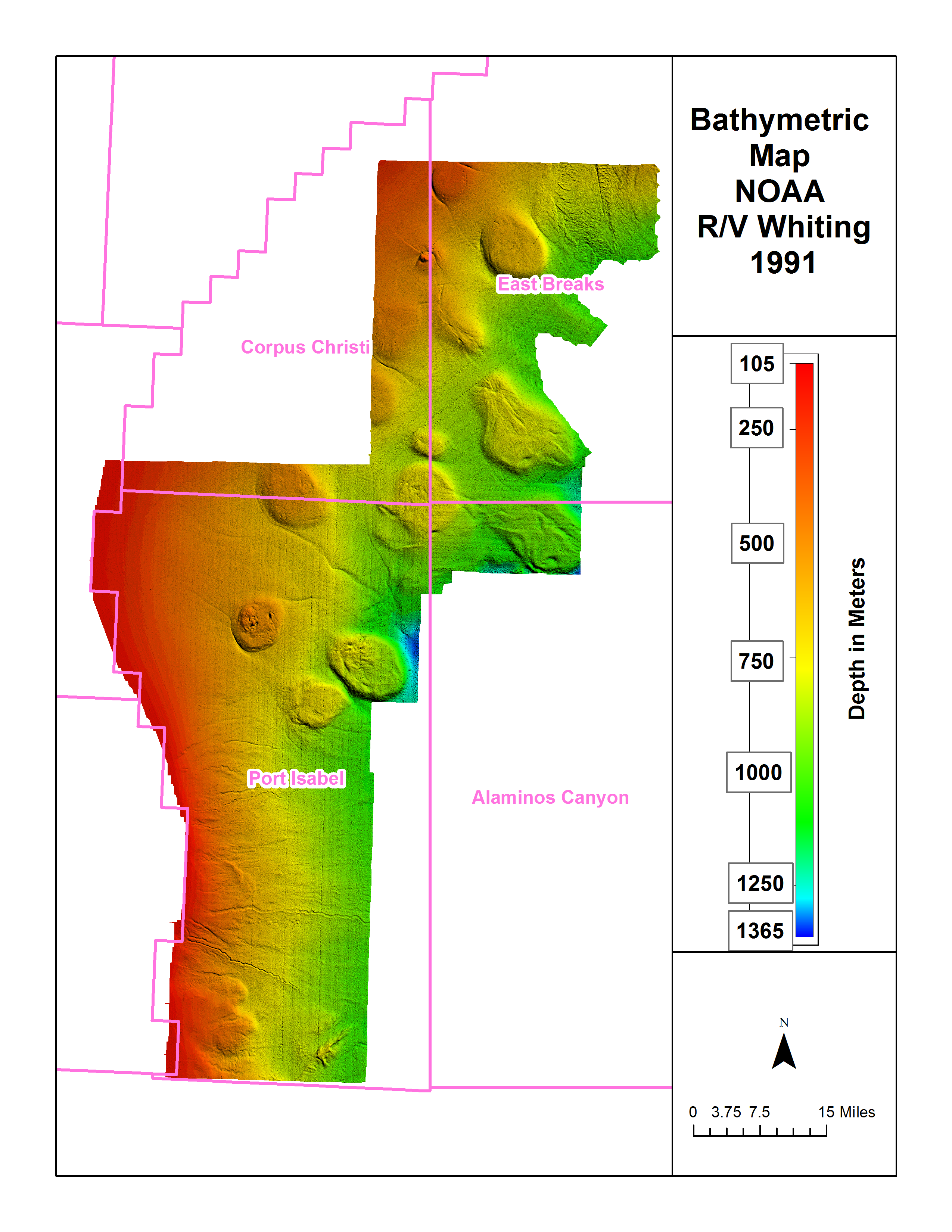
The main dataset that I'll be using is from the NOAA ship Whiting which collected multibeam data in the western gulf in 1991. This was downloaded as a series of xyz text files that were combined to make a surface in Global Mapper. The data is really noisy and as a cheat I binned it out to 50 meters and used some other GlobalMapper tricks to make the surface look reasonable. For 1991 data it's surprisingly good and you can resolve small channels and pockmarks. Figure 1 shows a bathymetric map of the study area. Unfortunately a large chunk of the Corpus Christi protraction area was unavailable.
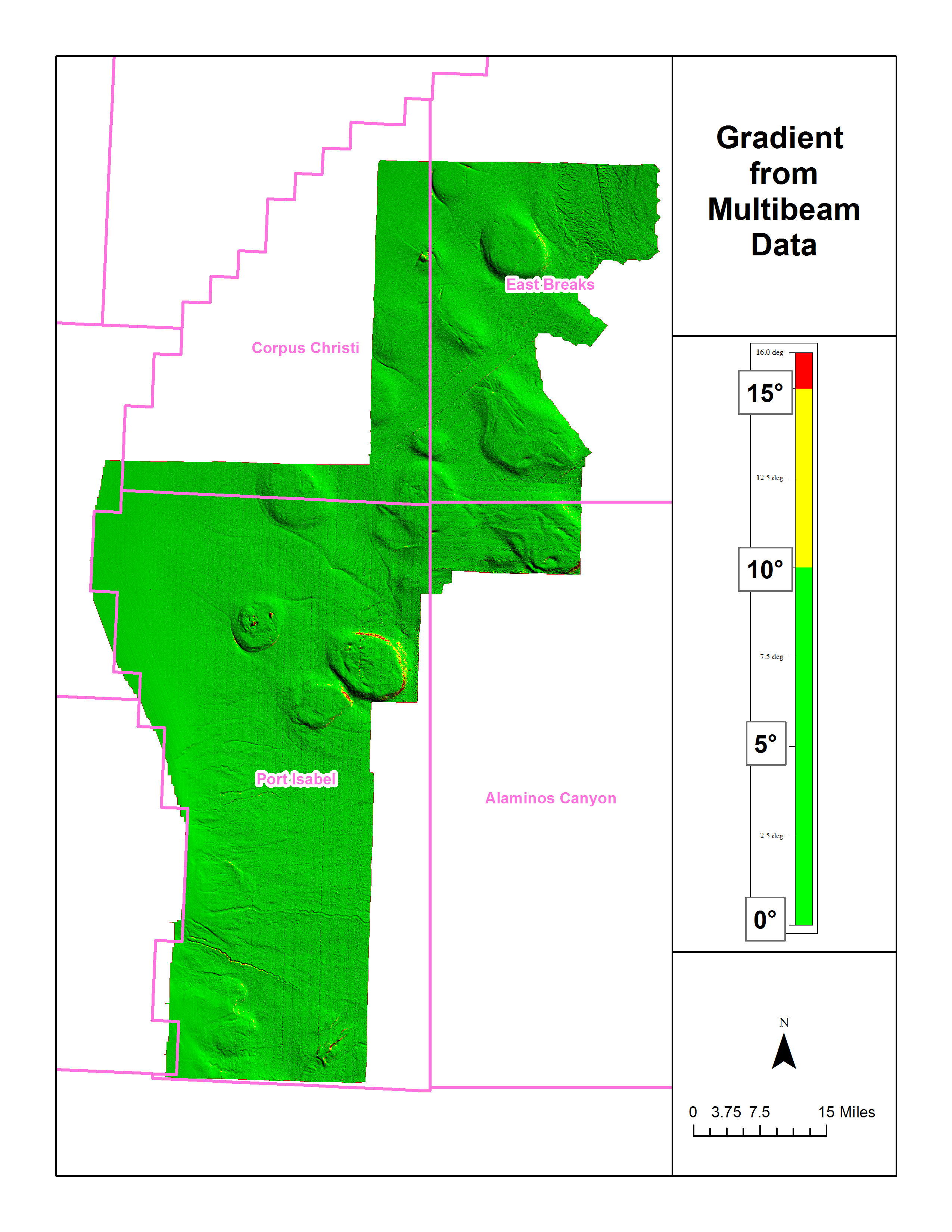
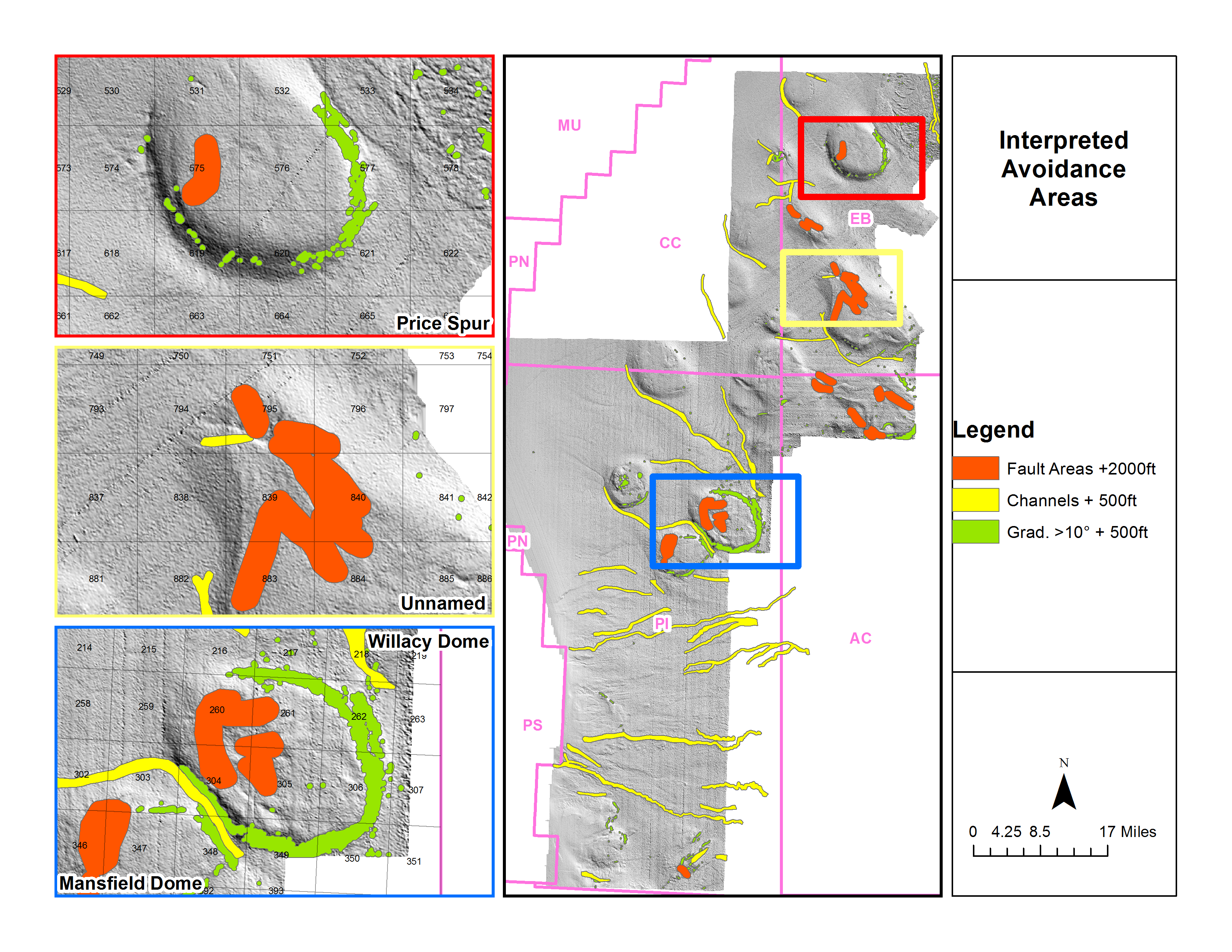
The first product from the multibeam is a gradient map. In this excericse I've considered any area that exceeds 10° to be unusable. This would be client specific of course. Most of these areas are found on the sides of the salt domes. In the north of the study area a buried MTD has a few areas that are >10°.
In addition to the multibeam I used the most recent BOEM hazard dataset, specifically these features:
There are several more classes of BOEM hazards but they didn't show up in the study area. Note – there are fans to the south east of the study area and there is an obvious area of mass transport deposits at the top of the study area. I have ignored these areas in this exercise. It doesn't look the the fan really impacts the surface, and the MTD would be more of a geotechnical problem for subsea structures than a reason not to drill an area (besides localized areas of high seafloor gradient).
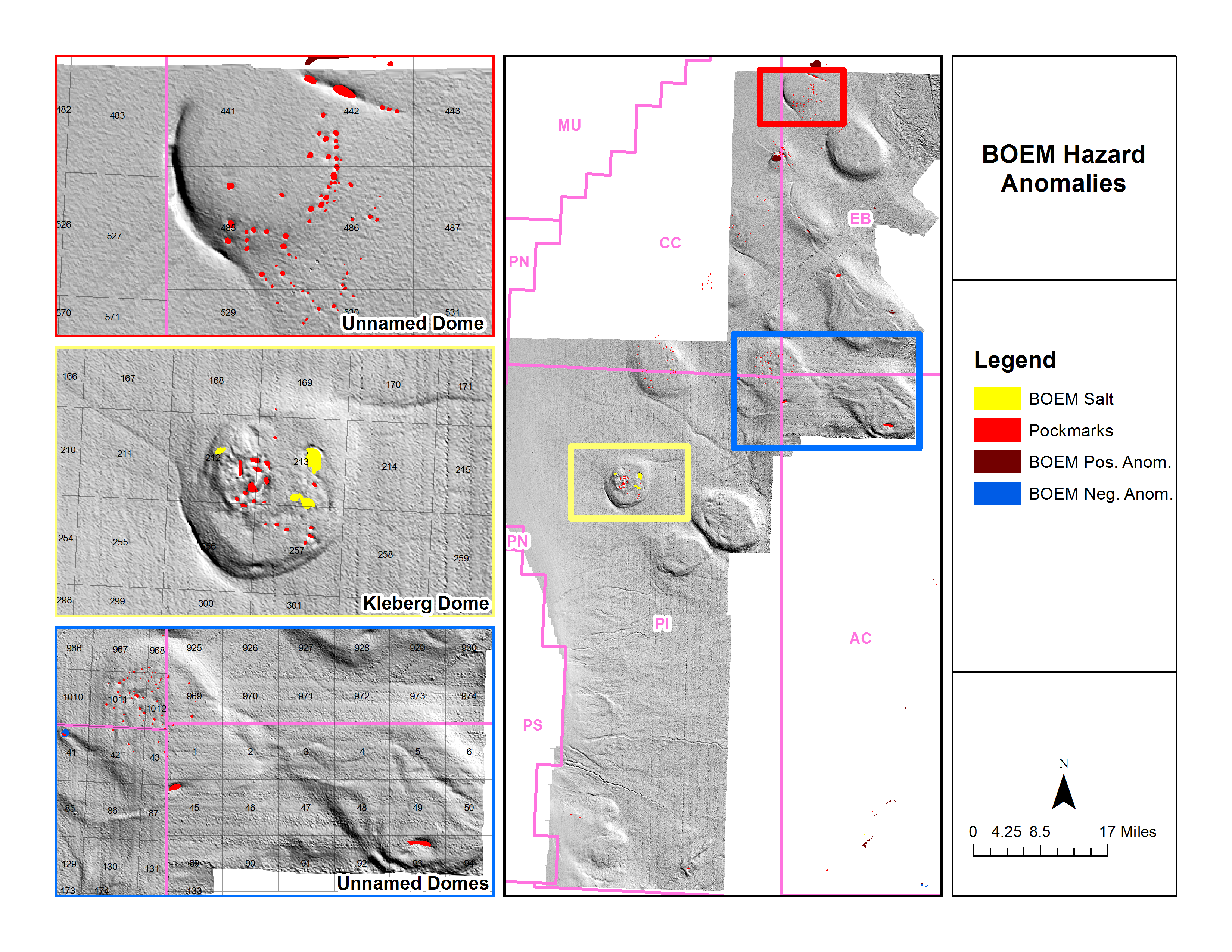
The next figure shows the salt, pockmark, and positive and negative anomalies. In the MBES data there were several noticeable pockmarks that were not in the BOEM dataset so I digitized them. The salt, positive, and negative data remained untouched.
The next figure shows the gradient areas >10°, areas interpreted as containing faults or graben areas, and channels.

“Fault areas” were digitized if they met any of the following criteria:
I will admit that it isn't actually clear on this dataset if these areas are actually faulted. It looks very similar to other areas in the GOM that are. I've pulled from my previous GOM experience where I have seen grabens associated with salt movement, typically on the up dip side of the salt domes. The hypothesis being that the salt domes are moving down dip, creating thrust faults on the down dip side, strike slip faults on the sides, and grabens from extensional forces on their up dip side. In my experience I have seen seeps and chemosynthetic communities associated along the graben and strike slip sides of a salt dome.
The examples in the figure above (Willacy Dome and the Unnamed Dome) do resemble other features in the GOM. The faults in the Unnamed Dome radiate from a large pockmark, and the faults in Willacy Dome are somewhat perpendicular to the vector of expected salt movement. It is my interpretation that these are extensional areas and seeps and chemosynthetic a would be found in these areas (if they still exist).
The following two figures take the data above and add avoidance radiuses to them. In the first figure we take all the BOEM salt, positive, negative, and pockmark areas and add a 2000 ft avoidance radius to them. Largely BOEM will expect no seabed wells to be installed near these areas.
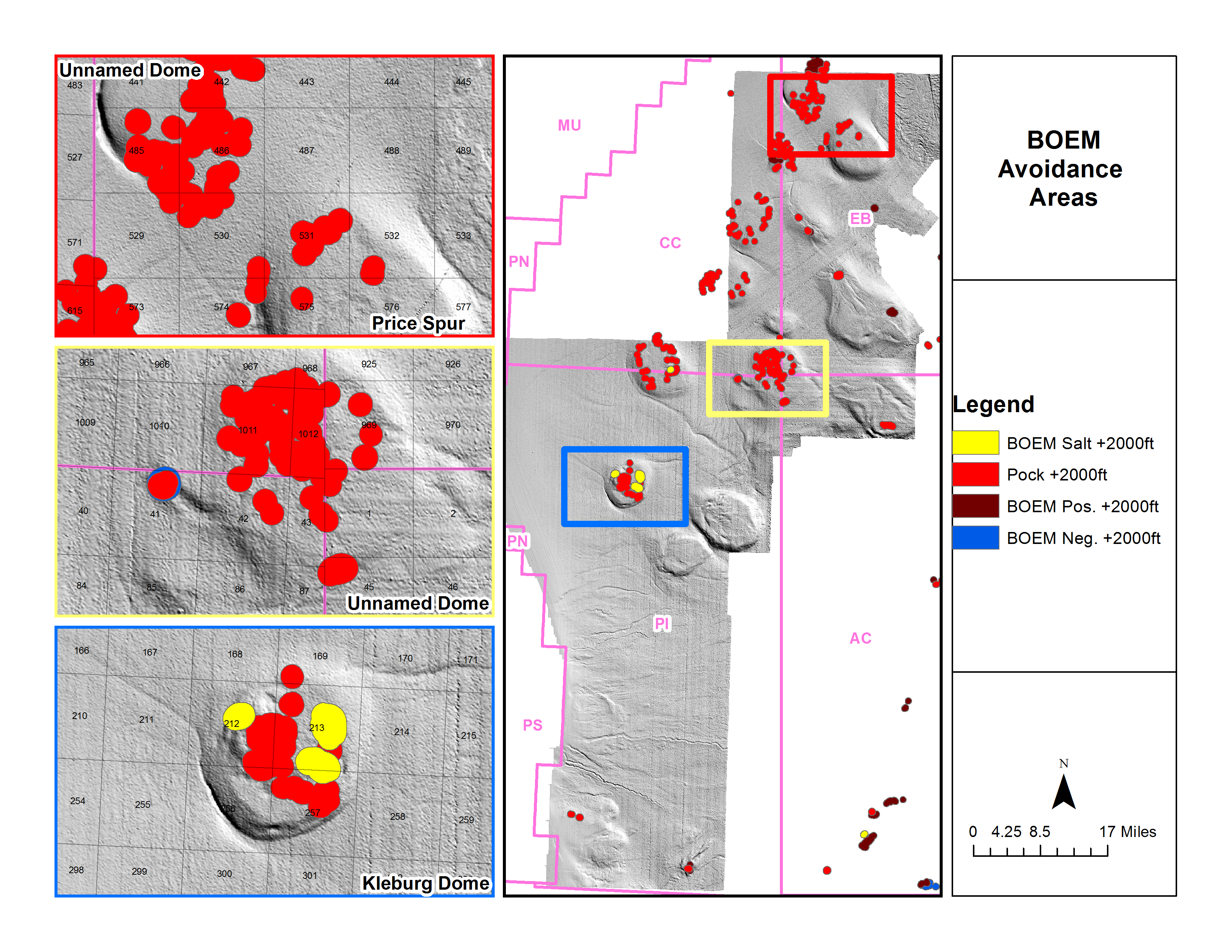
I should point out that pockmarks may or may not actually have any life in them. In this exercise we are treating pockmarks the same as we would treat “positive anomalies”. As there is no seep data for this area I cannot prove that these pockmarks are still active but I think it's not a stretch to say that these pockmarks are most likely to be from gas expulsion features- and therefore have a decent potential for chemosynthetic communities if still active.
The next figure contains avoidance areas for the fault areas, the channels, and the gradient areas.
The fault areas have a 2000 ft avoidance radius as we are treating these areas as possible chemosynthetic community sites. The channels and gradient areas are a little less clear as it would really be client specific, in this case I went with a 500 ft avoidance radius.
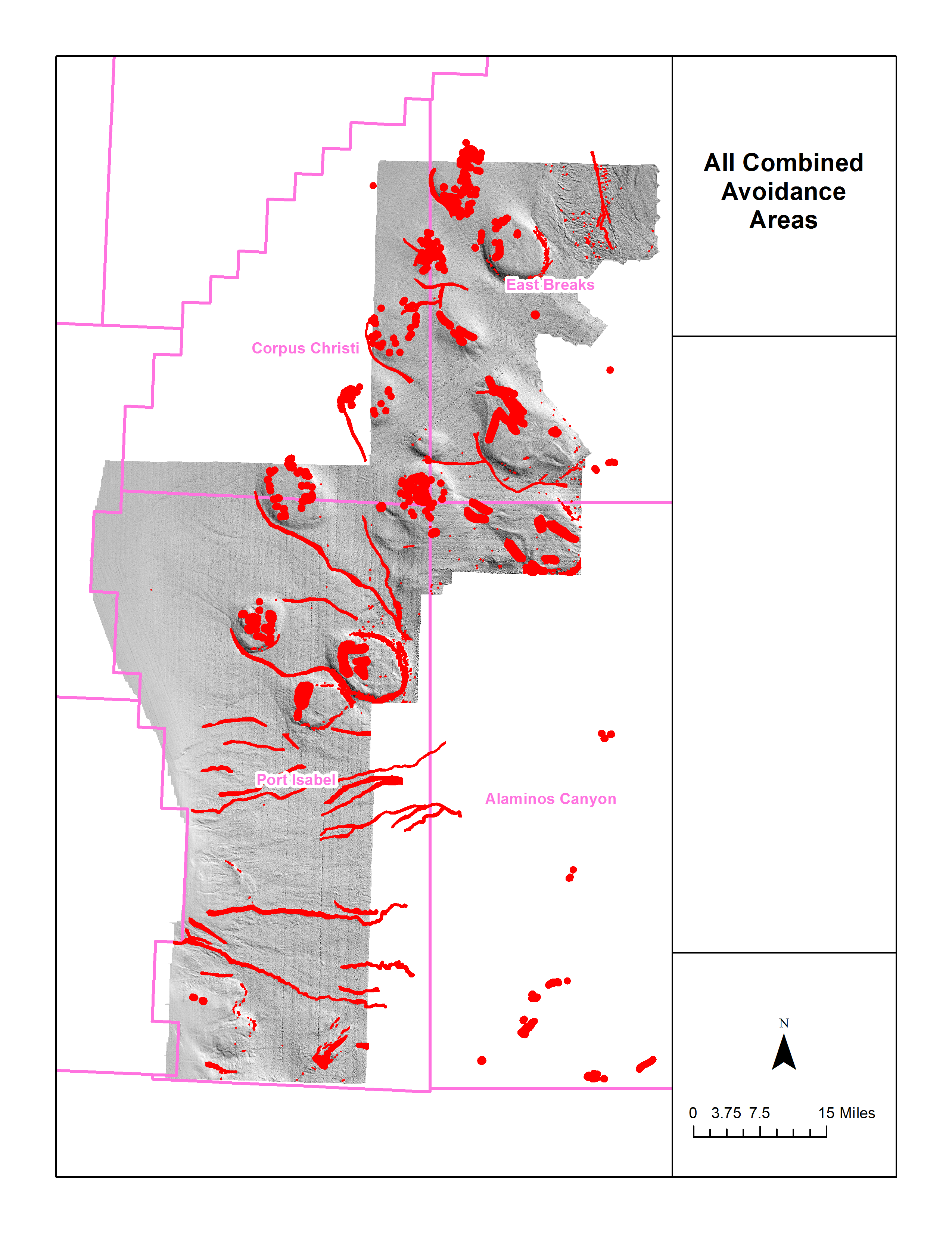
This next figure simply shows all the avoidance areas merged together.
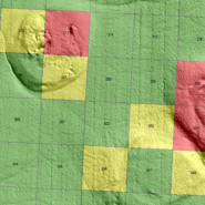
In the final figure I have simply taken the merged avoidance areas, split them by lease block, then determined the percentage of non available area on each block. Green blocks mean that 0-25% is in an avoidance area, yellow is 25-50%, and red is more than 50% of the seafloor would be unavailable to bottom disturbing activities.
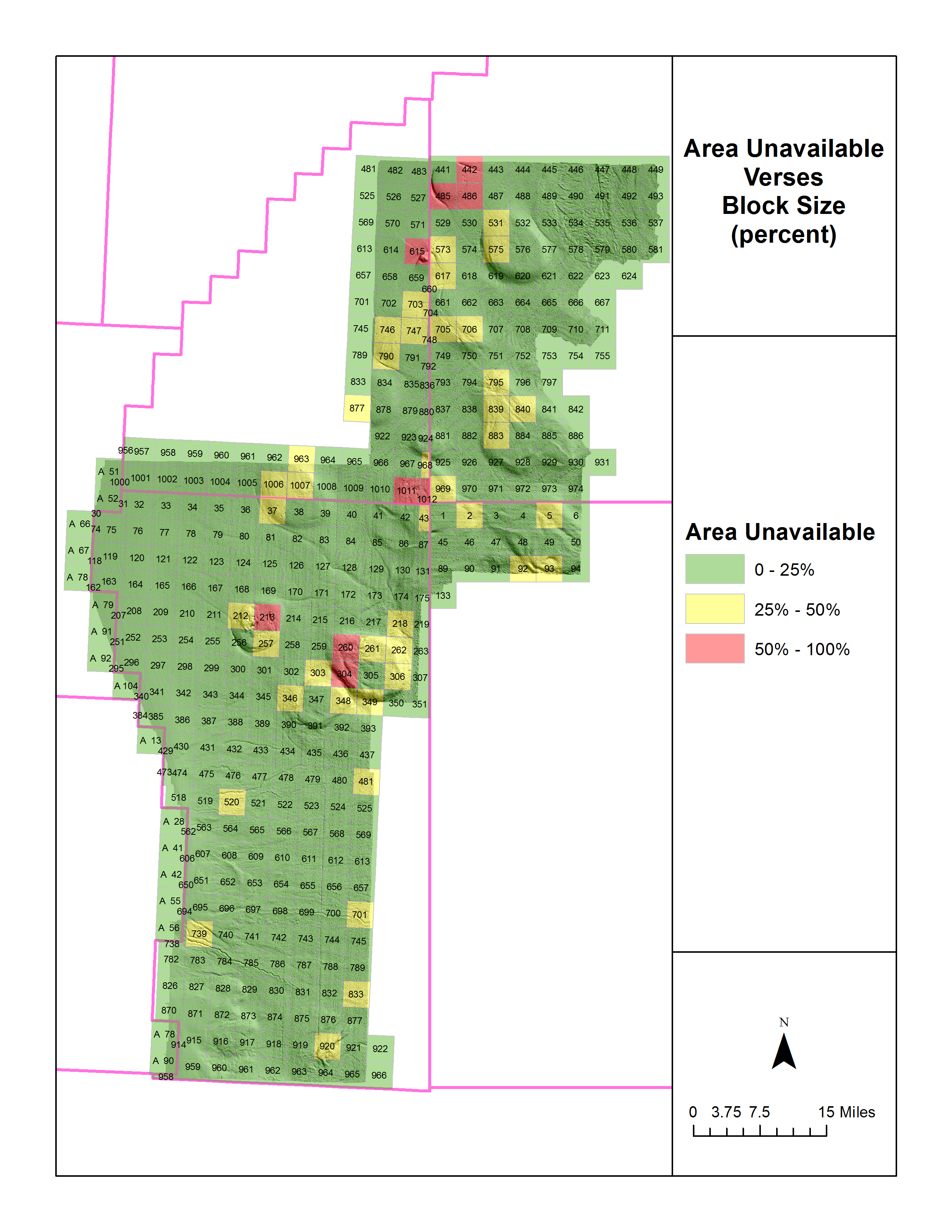
In this case the blocks with the highest amount of potential unusable space is Corpus Christi 1011 and 1012 with a predicted 71% and 98% unavailable. Most of the areas in this study are predicted to be clear.
It should be pointed out that I have done a separate but similar experiment in the Mississippi Canyon protraction area using modern NOAA multibeam/seep data. In that case several blocks were identified as having over 50% unavailable area. When plotted against the most recent well location data none of these blocks had wells. Unfortunately all the blocks were also leased. I believe that in the future pre-lease hazard surveys will become a normal procedure in their ability to find DHI in the form of seeps and also give an indication of where seafloor hazards might exist- and if the ability to drill actually exists.
For more information on how to use multibeam/seep studies as a regional indicator to hazards don't hesitate to email me at info@huxlabs.com
Recent Comments